Storm Pedro map: Where snow and ice will hit UK this week
Snowy and icy conditions are expected in parts of England with yellow weather warnings issued
The UK is bracing for a cold and wintry week as Storm Pedro is set to bring rain, ice, and snow across the country.
Yellow weather warnings for ice and snow covering much of Wales, as well as central and southern England, are in place from Wednesday afternoon to early on Thursday. Additional warnings for rain have been issued on the south coast between 6am on Wednesday and 8am on Thursday as wet weather is expected to batter coastal areas.
Met Office experts have warned spells of heavy rain and a period of snow could lead to some flooding and disruption to travel.
Some 10-20mm of rain is expected to fall widely, though areas near the south coast could see up to 30mm of rain, while Dartmoor, Devon, could be battered with as much as 50mm.

Forecasters said there is “potential” for an area of rain and snow to affect parts of Wales, central England and into the southern Pennines during Wednesday evening and overnight into Thursday.
Most of the snow is expected to accumulate on hills, with 2-5 cm anticipated “widely “above 150-200 metres. The Met Office said as much as 10-15 cm is possible above 250-300 metres in mid and southeast Wales, as well as Herefordshire, Shropshire and the southern Pennines.
It added lower elevations may see some small accumulations of snow of less than 2 cm from later Wednesday evening into the early hours of Thursday morning.
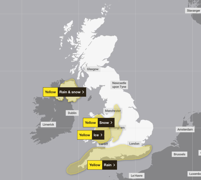
Icy weather could also cause disruption in parts of Wales and south west England, with forecasters warning of slips and falls on untreated surfaces.
Numerous places across Britain have been hit by flooding this year thanks to repeated heavy downpours.
Last month, Storm Chandra forced schools to close and disrupted everyday life.
Further cold weather warnings have been issued by the UK Health Security Agency across parts of England from 6pm on Tuesday evening until 6pm on Friday.
The agency said the weather was likely to lead to higher demand on healthcare services by vulnerable people, as well as a greater risk to life of vulnerable people.
The Met Office yellow weather warning for snow covers parts of Wales and the west of England, including Birmingham and Worcester, from 4pm on Wednesday until 6am on Thursday.
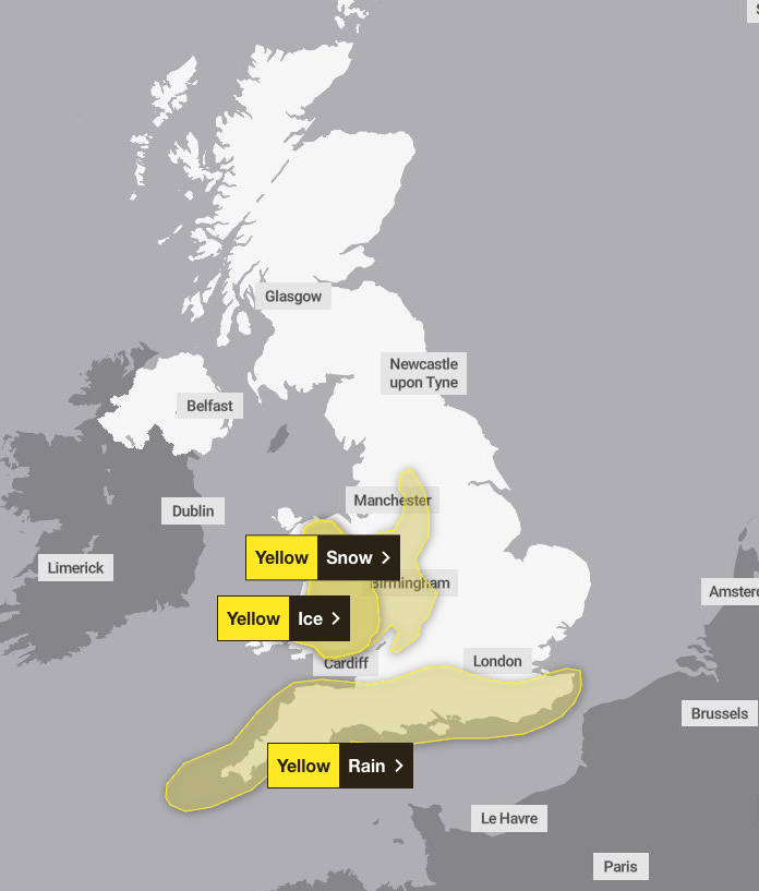
The yellow weather warning for rain covers southern parts of England, stretching from Kent to Cornwall, between 6am on Wednesday and 8am on Thursday.
Strong winds will accompany the wet weather, which could exacerbate the effects in places, the Met Office said.
Deputy chief forecaster Steven Keates said: “Initially, we may see some snow over the highest parts of southern England, such as Dartmoor, but the main chance of snow will be across higher parts of the Midlands and mid- and southeast Wales.”
He said a sharp frost was likely across parts of Scotland on Wednesday morning, with some further frost and ice in places overnight into Thursday.
The UK Health Security Agency yellow cold health alert, issued for the East Midlands, West Midlands, North East, North West, South West, east of England and Yorkshire and the Humber, is place from 6pm on Tuesday until 6pm on Friday.
Senior Met Office meteorologist Craig Snell said many will be see “a very wet and windy morning” on Wednesday, but added those in northern England will be “wondering what’s going on” – with a dry day expected for many.
Mr Snell said: “By the time we get into the late part of the day on Thursday, by that stage, the winds should be clearing away and Thursday will just be a slow improvement day.
“It’s all change after that, by the weekend it will be feeling much, much milder with temperatures reaching the low-to-mid teens, if we see some sunshine.
“There will be further spells of wind and rain but most of us will certainly see an uplift of temperatures as we go into the weekend.”
Join our commenting forum
Join thought-provoking conversations, follow other Independent readers and see their replies
Comments
Bookmark popover
Removed from bookmarks