UK suffers 36 continuous days of rain as miserable weather continues with more Met Office warnings
Not long after Storm Chandra brought deluge to parts of the UK, the country is expecting even more wet weather
The UK has seen rain every single day so far this year, with more expected as the Met Office issued fresh weather warnings.
Rain has been reported somewhere across the Met Office’s network every day of the year so far, amounting to 36 consecutive days, after the forecaster recorded a wetter than average January.
Met Office spokesperson Stephen Dixon said: “Rain has been reported somewhere in the network every day of the year so far. While amounts are trivial on some days, and some areas will have seen dry days, the UK has seen a wet start to the year, particularly in Northern Ireland and southern England.
“This has largely been down to a succession of fronts or low pressure systems arriving from the west, bringing heavy rain at times, as well as damaging winds for some. There’s little sign of a let-up in the current forecast, with further unsettled weather in the coming days and over the weekend.”
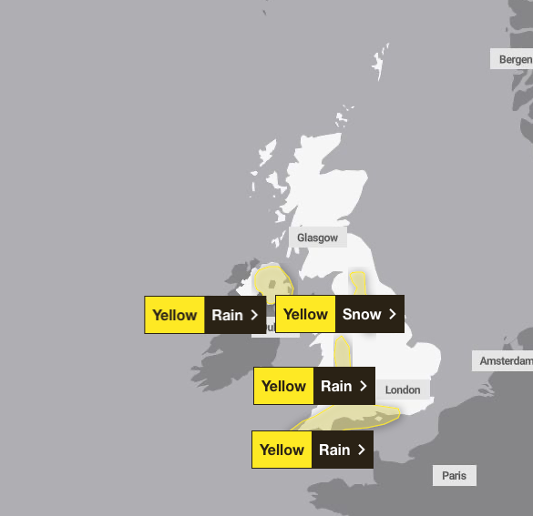
The wet weather looks set to remain as two yellow weather warnings for rain have been put in place across southwest England, Wales and Northern Ireland.
A third yellow weather warning for snow has been issued for the north of England as “rain will turn increasingly to snow over hills through this afternoon and evening” between 3pm on Thursday and 3am on Friday, which may lead to some travel disruption, the forecaster said.
A yellow rain warning stretches from Chichester to Penzance and covers a large part of southeast England, as well as parts of southwest England and south Wales, from 5am on Thursday until 9pm on Friday.
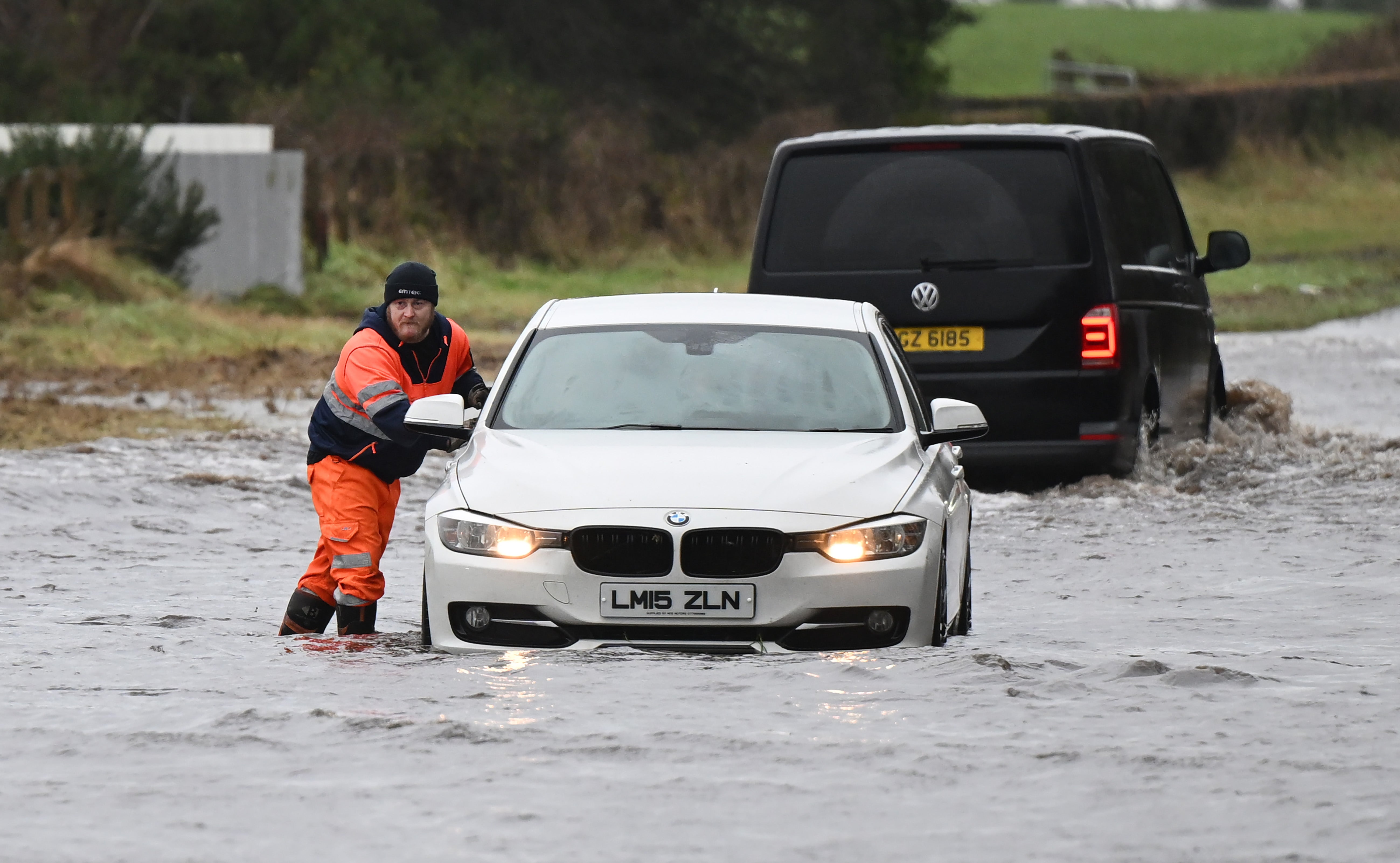
The Met Office said “periods of rain and heavy showers are likely to cause surface water flooding in places” in the areas affected. The rain travelling in from the south is likely to turn “heavy and persistent” in places on Thursday morning, it said. Some 10 to 20mm of rain is likely to have fallen by the end of the day, with some areas seeing more than 30mm.
The forecaster warned that flooding of a few homes and businesses is possible, with a potential interruption to power supplies and other services.
A second yellow weather warning is in place across parts of Northern Ireland from midday until midnight on Friday. The forecaster warned that“rain will be heavy at times and may lead to some flooding and travel disruption in places”.
The Met Office added: “The majority of places are most likely to see 10 to 20mm of rain and low-level impacts, with some south-east facing hills seeing 40 to 50mm through this period.”
The wet weather is expected to be particularly persistent over the east and southeast facing slopes of the Mourne Mountains and Antrim Hills, which may receive 60 to 80mm, accompanied by strong east to south-east winds may lead to some difficult travel conditions and large waves along Irish Sea coasts.
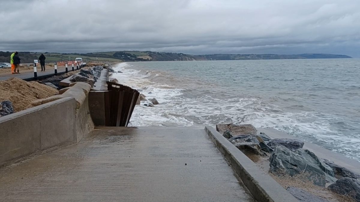
It comes as Northern Ireland recorded its wettest January in 149 years – the second wettest on record. Storm Chandra brought record-breaking rainfall across a number of UK sites, especially on 26 January, with Katesbridge in County Down seeing a staggering 100.8mm of rain, far surpassing the previous site record of 38.2mm from 2005.
Dunkeswell Aerodrome in Devon reached 52.8mm, while Hurn in Dorset, Cardinham in Cornwall, and Plymouth Mountbatten in Devon all exceeded their previous daily records.
Join our commenting forum
Join thought-provoking conversations, follow other Independent readers and see their replies
Comments
Bookmark popover
Removed from bookmarks