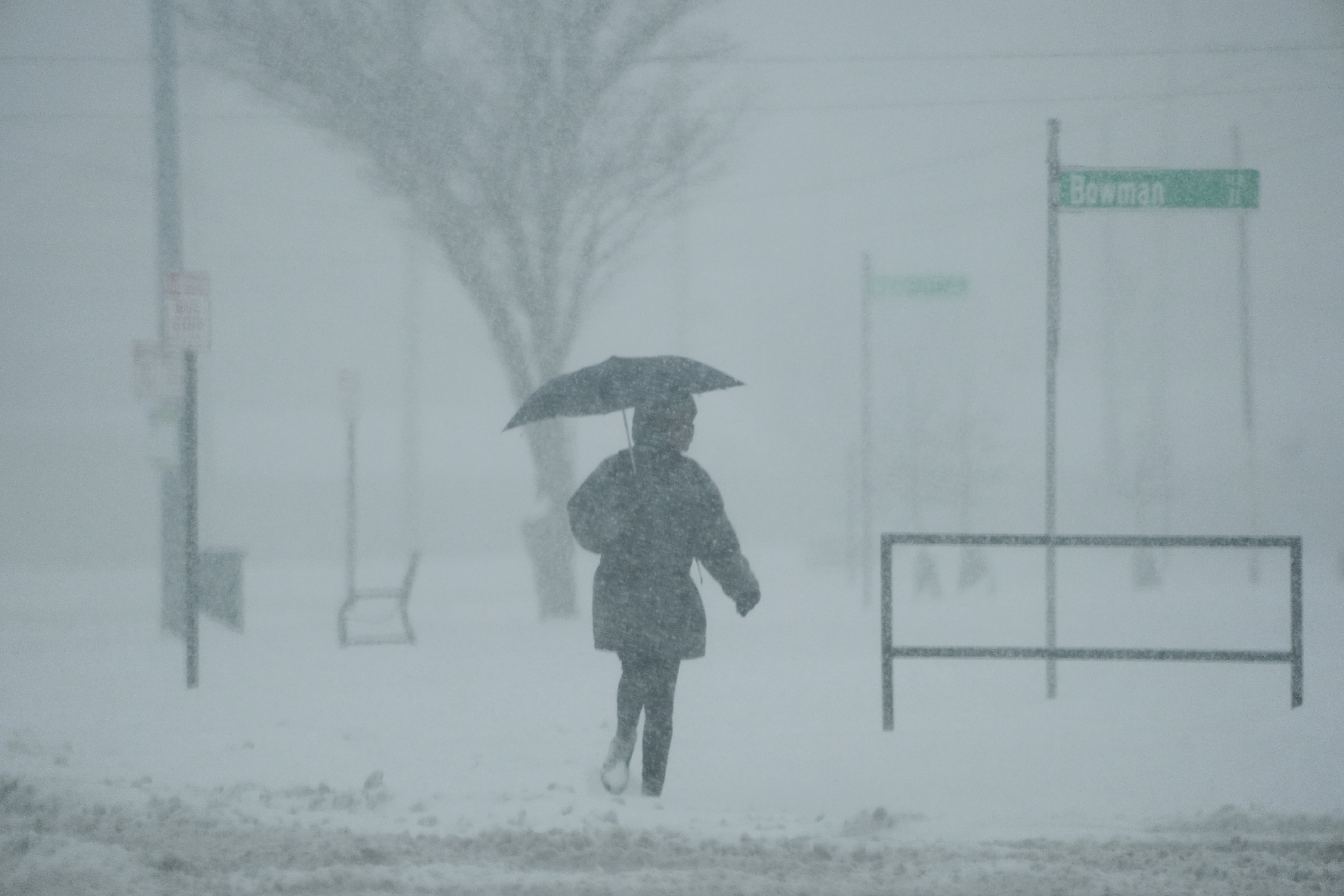
Millions of Americans to face freezing temperatures and snow as Polar Vortex brings Arctic cold
Floods, rainfall and arctic cold is set to batter parts of the United States

Millions of Americans are set to be hit by Arctic cold and heavy rain, with forecasters warning of extreme weather conditions ahead of the holidays.
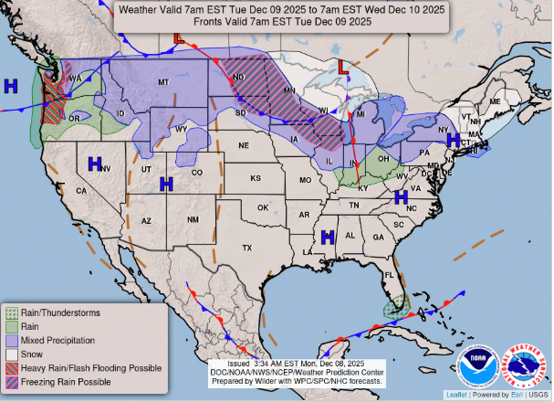
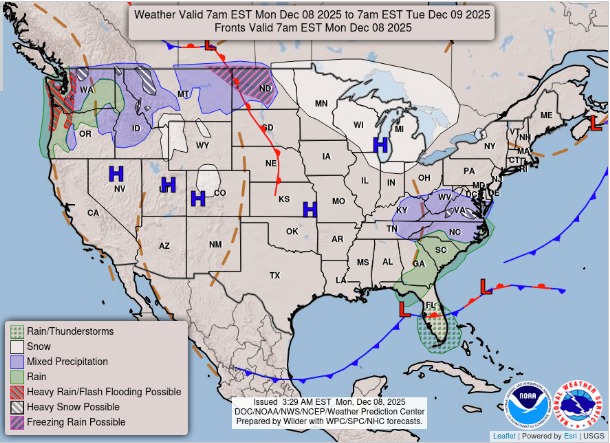
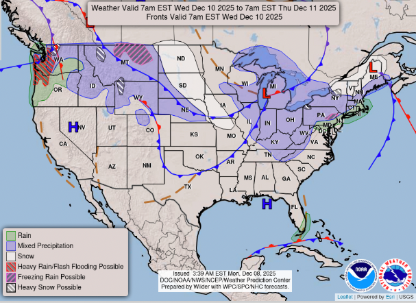
The U.S. National Oceanic and Atmospheric Administration’s Weather Prediction Center has issued multiple alerts for states including Oregon, Washington, Idaho, Montana, Michigan, Washington D.C., Pennsylvania and New York.
Freezing temperatures well below the annual average are expected in parts of the Midwest and East Coast, with a winter storm warning in place that could see snowfall.
“A winter storm warning is now in effect over portions of south-central Virginia (including the Richmond metro) for 3-5 inches of snowfall through this evening,” the center said in a statement. “Adjacent areas in the Appalachians and southern Mid-Atlantic should see 1-2 inches of snowfall, where winter weather advisories are posted.”
An AccuWeather forecast says there will be further cold waves expanding from central Canada, the Midwestern and eastern U.S. states, because of a breakdown of the polar vortex. A polar vortex is a low-pressure area that can expand into the Northern Hemisphere during the winter months, bringing freezing cold temperatures with it.
A breakdown of the vortex – also called a Sudden Stratospheric Warming – occurs when cold winds rapidly weaken, causing the vortex to split or shift, which disrupts the jet stream and allows frigid Arctic air to plunge south, bringing severe cold and snowstorms.
AccuWeather Lead Long-Range Meteorologist Paul Pastelok said the polar vortex has been weakened since late November.
“We are seeing the result as Arctic air pushes southward across the central and eastern U.S. in recent days and may continue to do so for the next couple of weeks or so in waves,” he said.
Temperatures are predicted to drop below zero Fahrenheit on Monday, roughly 15 to 25 degrees below the historical average, according to AccuWeather.
“We believe that two to three more rounds of intense cold are possible from the Midwest to much of the East, spanning December 10 to 19,” Pastelok said. “There is a chance for a frost or freeze late next week as far south as central Florida.”
More than a foot of snow is expected to fall in high-elevation areas in the Cascade and Northern Rocky Mountains, according to USA Today.
Elsewhere, bouts of heavy rain are expected in the coming days. For the Pacific Northwest states, there is a predicted 6 to 12 inches of rainfall for the week.
In a post to X, the Weather Prediction Center said there will be prolonged rainfall and potential flooding because of a “potent and long duration atmospheric river”.
An atmospheric river is a long, narrow band of concentrated water vapor in the atmosphere, transporting moisture from the tropics to higher latitudes similar to a “river in the sky”.
“Urban and small stream flooding may occur, as well as riverine flooding with excessive water run-off,” the post stated.
“Coastal locations could see 4-6 inches for rainfall accumulations, and upwards to 8-12 inches of precipitation in the mountain ranges (snow in high terrain).”
In a media release, the Weather Prediction Center said on Monday that a prolonged atmospheric river is set to begin.
“Rainfall coverage and intensity is expected to increase across coastal Washington and Oregon as a potent slug of sub-tropical moisture begins to flow inland along a strong Pacific jet,” the statement said.
“Isolated to scattered instances of flash flooding are possible with this activity through midweek, where a slew of flood watches are in effect. Rainfall aside, parts of the Pacific Northwest, Northern Rockies and Northern Plains can also expect a period of gusty winds today and Tuesday.
“As this clipper system ejects eastward into the Northern Plains and Upper Midwest late Tuesday, wintry weather should develop along the northern flank of the low center. While there remains uncertainty in forecast amounts, at least a few inches of snowfall and freezing rain are possible roughly along a Fargo to Grand Rapids line.”
Join our commenting forum
Join thought-provoking conversations, follow other Independent readers and see their replies
Comments
Bookmark popover
Removed from bookmarks