UK weather map: Met Office issues weather warnings with flooding possible
The Met Office has issued a number of yellow and amber weather warnings for rain across the country
Several weather warnings are in force across the UK as heavy rain could bring a risk of flooding.
The Met Office has issued a number of yellow weather warnings – and one amber – for rain, covering various parts of the country over Monday and Tuesday.
The amber warning for rain covers much of South Wales, spanning from St David’s on the west coast to Chepstow in the east, spanning north to the edge of Llandovery.
The warning is in force from 3am to 9pm on Monday, and the Met Office forecasts that heavy rain could lead to travel disruption and flooding.
The Met Office said: “Heavy rain is expected across parts of south and south-west Wales during Monday.
“50 to 80mm of rain is likely to fall quite widely with some places seeing close to 100mm. Given the recent wet weather and saturated ground, the likelihood of impacts is higher.”
It adds that homes and businesses are likely to be flooded, stating: “Fast flowing or deep floodwater is likely, causing danger to life.”
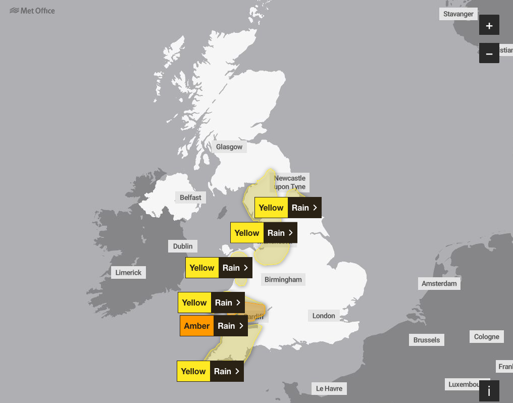
A yellow warning overlaps with the amber area, though it spreads further north to Llanwrtyd Wells.
Yellow rain warnings are in place up and down the country. One covers large parts of north-west England, north Wales and the Midlands, as well as parts of Yorkshire. It has been in force since 6pm on Saturday and will remain until 11.59pm on Monday.
Similarly, the South West - from Taunton to the Devon and the Cornish coasts - is covered by a yellow warning until 11.59pm on Monday.
A yellow warning for rain covering Ceredigion, Conwy, Denbighshire, Gwynedd and Powys in Wales will remain in force until 3pm on Monday, having started at 6pm on Sunday.
A warning is also in place for north east England, around Darlington and County Durham from 6am on Monday to 3am on Tuesday.
Wednesday will see a yellow rain warning from 10am to 11.59pm, covering south Wales and south-west England, as well as some of the West Midlands.
Regarding the warnings, the Met Office says: “Numerous severe weather warnings have been issued for rain as it will persist through the weekend and into the start of next week. Amber warnings for rain have been issued for south Wales, and Cumbria where accumulations are particularly notable, with potentially over 200mm of rain over 48 hours.
“More widely, totals of 40 to 70mm are likely, with over 100mm on higher ground of western Britain and up to 50mm possible over higher ground in Northern Ireland.”

Jonathan Day, flood duty manager at the Environment Agency, said: “Significant surface water flooding impacts are possible in parts of the North of England on Saturday, Sunday and Monday.
“There are also possible significant river flooding impacts in parts of the North of England on Sunday and Monday, with minor flooding impacts possible more widely across northern England over the weekend.
"Environment Agency teams are out on the ground, taking action to reduce the impact of flooding and support those communities affected. We urge people not to drive though flood water – it is often deeper than it looks and just 30cm of flowing water is enough to float your car. “
Met Office five-day forecast for the UK
Monday:
Heavy rain will linger for much of the day across northern England, Wales and south-west England. Flooding is likely in places. Dry elsewhere, with the best of the sunnier moments across Scotland and Northern Ireland. Breezy and mild in the South.
Monday night:
The rain will continue across parts of England and Wales this evening, edging slowly east overnight. Dry elsewhere, with clear spells. A patchy frost will form across Scotland and Northern Ireland.
Tuesday:
Patchy rain gradually clearing eastern England through the morning. A dry and bright day for many, with a few blustery showers across north-west Scotland. Feeling colder than of late.
Outlook for Wednesday to Friday:
Turning wet and windy once again through Wednesday, lingering into Thursday. Drier and brighter for Friday, though with a scattering of showers. Near average temperatures, mild in the far south.
Join our commenting forum
Join thought-provoking conversations, follow other Independent readers and see their replies
Comments
Bookmark popover
Removed from bookmarks