Storm Chandra map: Where heavy rain and flooding could hit UK today with ‘danger to life’ warning issued
Several weather warnings have been issued, including an amber wind warning for the eastern coast of Northern Ireland
Strong winds, heavy rain and snow are forecast across much of the UK on Tuesday, the Met Office has warned, as the newly named Storm Chandra brings weather chaos.
Storm Chandra is expected to hit with “very strong winds”, which may damage buildings and dislodge tiles that could cause life-threatening injuries.
Several weather warnings have been issued, including an amber warning for wind along the east coast of Northern Ireland and including Belfast.
Less severe yellow weather warnings are in place across all of Northern Ireland, a more extensive area of southwest England, and also cover parts of Scotland.
The Met Office said: “Easterly winds will increase early on Tuesday morning bringing gusts of 60-70 mph to eastern and northern parts of Northern Ireland with a few coastal locations seeing gusts of 75 mph. Heavy rain will be an additional hazard.
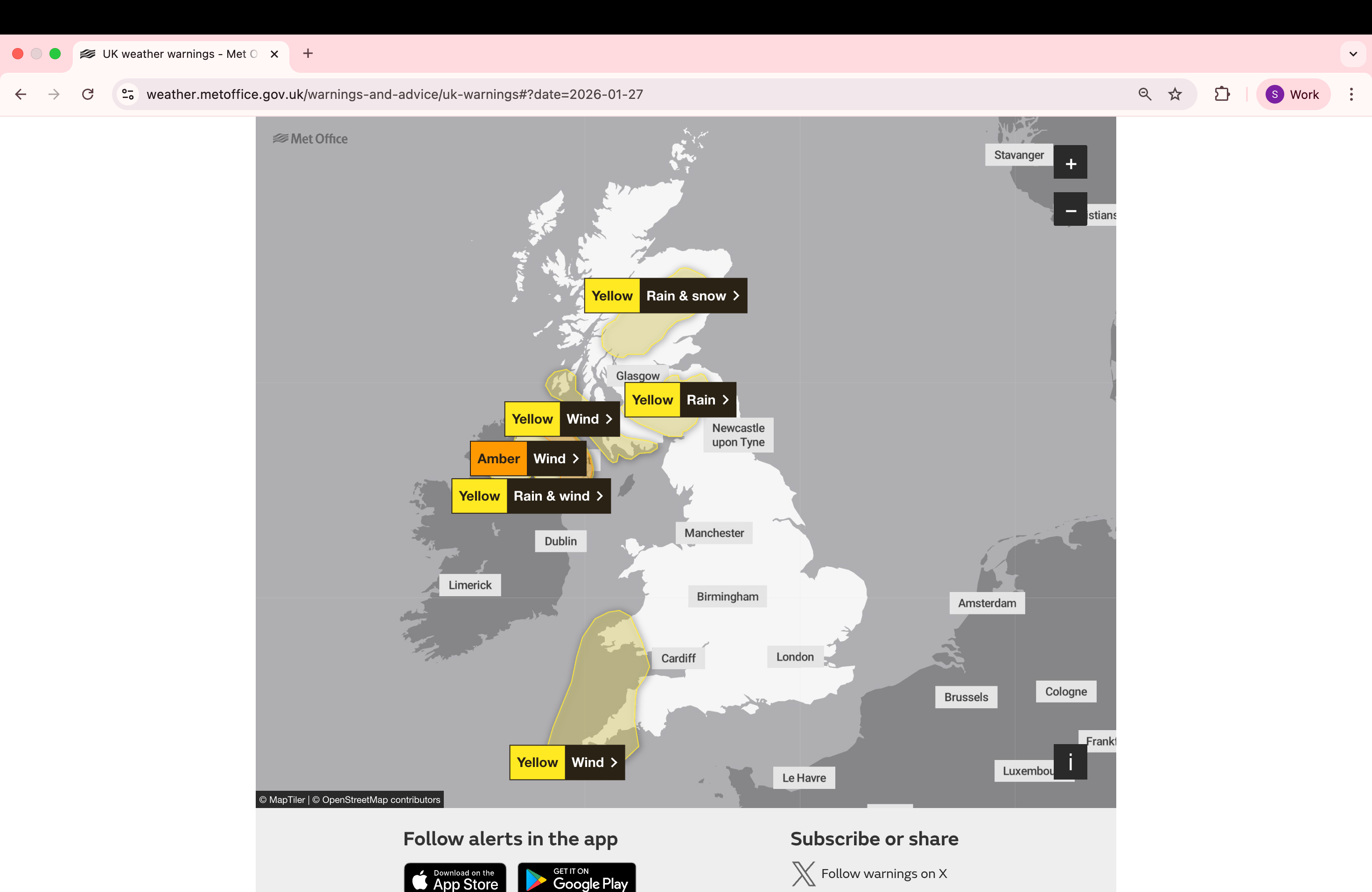
“Winds may ease a little early in the afternoon, before increasing to similar speeds once more from a south-easterly direction late afternoon and early evening.”
A severe flood warning, indicating that floods pose a danger to life, has been issued for the River Otter in Ottery St Mary, near Exeter.
In coastal areas, large waves could throw beach material onto nearby roads, along the sea front and properties, posing a “danger to life”. If you are on the coast, the Met Office advises staying safe during stormy weather by being aware of large waves, as even from the shore, large breaking waves can sweep you off your feet and out to sea.
The weather service has warned coastal residents to take care if walking near cliffs; saying people should know their route and keep dogs on a lead. In an emergency, they are advised to call 999 and ask for the coastguard.
Longer journey times and cancellations are expected to impact road, rail, air and ferry services, as well causing some roads and bridges to close.
Driving in these dangerous conditions is not advised and the forecasters suggest staying indoors as much as possible to avoid being vulnerable to injury from high winds.
.png)
Ice is expected to form overnight Tuesday and may lead to some disruption through to Wednesday morning across the UK, the Met Office has warned.
The Met Office stated: “Clearing skies Tuesday night will allow temperatures to fall below freezing on Wednesday morning and, after the recent very wet weather, icy patches are likely to develop on some untreated surfaces.”
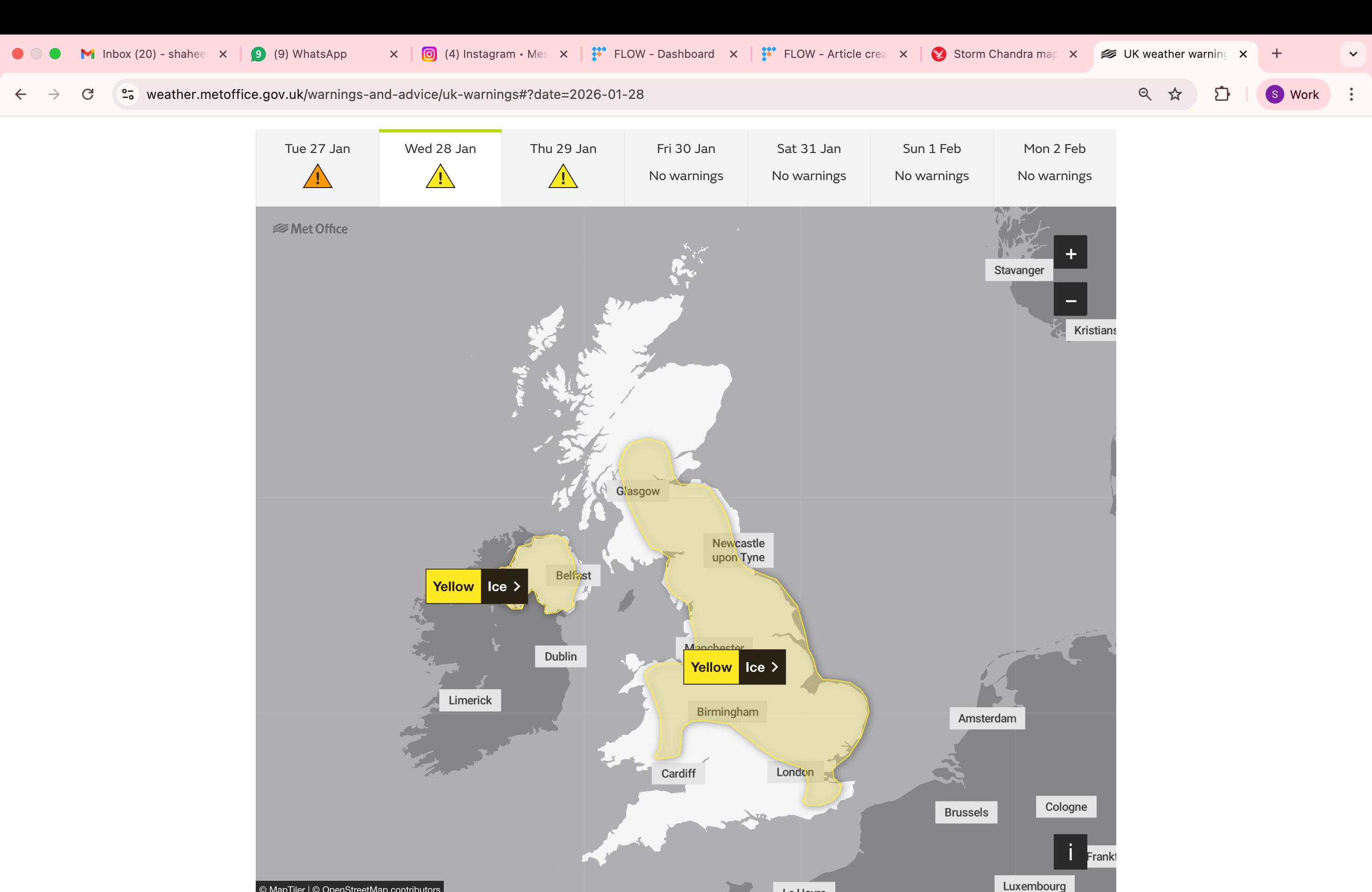
The regions affected by the yellow weather warning for ice on Wednesday include parts of Northern Ireland, central England, the East Midlands, the east of England, London and South East England, North East England, North West England, Scotland and Lothian borders, Strathclyde, Wales, West Midlands, and Yorkshire and Humber.
Further rain is predicted on Thursday to lead to more flooding and transport disruption in southwest England.
There is a small chance of fast flowing or deep floodwater to cause a danger to life, the Met Office has warned.
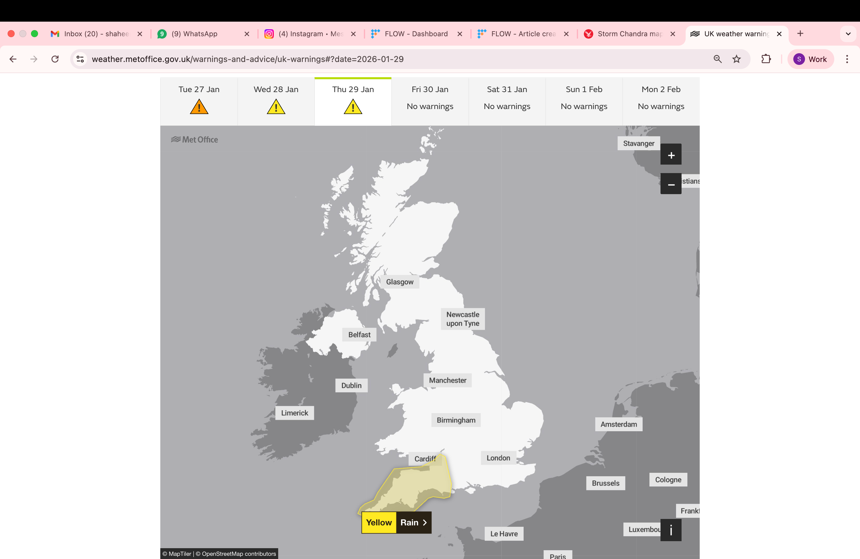
The Met Office said: “A band of rain is likely to reach southwest England on Thursday afternoon then spread quickly northeast across the rest of the warning area by evening. The rain is only likely to last for a few hours in any one location but will be heavy at times.
“A further 10 to 20 mm is likely quite widely, and in the wetter spots, particularly across the moors, a further 20 to 40 mm is possible and will fall onto already saturated ground.”
Join our commenting forum
Join thought-provoking conversations, follow other Independent readers and see their replies
Comments
Bookmark popover
Removed from bookmarks