Snow to hit UK as Met Office issues yellow weather warning
The UKHSA has also issued a cold weather health alert across the majority of England
The UK is expecting to see snow once again after the Met Office put a yellow weather warning in place and health chiefs issued a cold health alert.
The alert from the UK Health Security Agency (UKHSA) is in place from 6am on Friday until 8am on Monday, covering the South West, the Midlands, the North East, the North West and Yorkshire and the Humber.
It warned the cold conditions are likely to pose "a greater risk to life of vulnerable people" and increased use of healthcare services.
As much as 15cm of snow is expected to fall in Wales and the West Midlands on Wednesday and Thursday, according to the Met Office.
The snowy, wintry weather could cause travel disruptions, with bus and train services likely to be affected with longer journey times, delays and cancellations due to dangerous conditions and ice on road surfaces.
The forecaster also warned some rural communities could be cut off and there is a chance of power cuts, while mobile phone coverage could be affected.
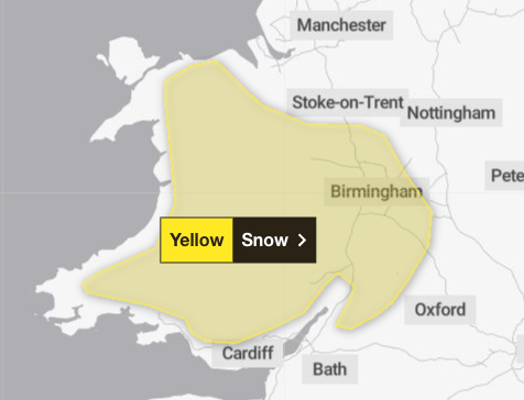
The yellow weather warning for snow is in place from Wednesday at 4pm until Thursday at 6am. Wales, the West Midlands, parts of Oxfordshire and Gloucestershire are also affected by the warning.
Forecasters have said 2 to 5cm of snow could accumulate quite widely above 150 to 200m, with perhaps as much as 10 to 15cm above 250 to 300m in mid- and south-east Wales, as well as Herefordshire and Shropshire.
Some small accumulations of snow, typically less than 2cm, are possible on lower ground, especially from later Wednesday evening into the early hours of Thursday morning.
Strong east to north-easterly winds are also expected to accompany the wet weather.
The national forecaster has advised drivers to keep themselves and others safe by planning their route and allowing extra time to make their journey. Additionally, people are advised to check for road closures or delays to public transport, and amend plans if necessary.
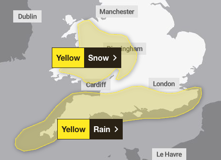
A yellow weather warning has also been issued for rain across the south of England from Wednesday at 6am to Thursday at 8am.
Heavy rain across Sussex and Kent all the way to Cornwall could lead to flooding and disruption to travel. But snow is also likely on higher ground on Wednesday night across this region.
As much as 20mm of rain is expected quite widely, with a few places near the south coast seeing 20 to 30mm and perhaps as much as 50mm over Dartmoor, according to the Met Office.
Strong winds will accompany the rain and snow, and large waves could affect some east-facing coasts, especially along the English Channel.
Met Office five-day weather forecast
Tuesday
A cold and frosty start, but for many it will be a dry and sunny day today. A few wintry showers may affect the far North and North Sea coasts, with cloud and rain reaching the far South West later.
Overnight
Cloud and rain across the far South West extending into southern England, Wales and Northern Ireland, with some snow possible over hills. Mostly dry elsewhere with a frost developing.
Wednesday
Mostly dry across Scotland and northern England with spells of sunshine. Outbreaks of rain and mainly hill snow elsewhere, with southern areas becoming windy with coastal gales. Feeling cold.
Outlook for Thursday to Saturday
Rain and snow clearing the South on Thursday, leaving a mainly dry and bright day. Turning milder from Friday but with further bands of wet and windy weather moving eastwards.
Join our commenting forum
Join thought-provoking conversations, follow other Independent readers and see their replies
Comments
Bookmark popover
Removed from bookmarks