At 3.2C, Delhi wakes up to coldest January morning in 3 years as cold wave grips north India
The plunge in temperatures has made parts of northern India colder than several Himalayan hill towns
Delhi experienced its coldest January morning in three years this week as the temperature dropped to around 3 degrees Celsius and a cold wave gripped much of the country’s north-western plains, according to India’s weather office.
Near-freezing temperatures were recorded in cities across Haryana, Punjab and Rajasthan, while the satellite city of Gurugram in India’s national capital region recorded the near-freezing temperature of 0.6C – one of its lowest in nearly five decades.
The plunge has made parts of northern India colder than several Himalayan hill towns, an unusual reversal that has left the region shrouded in dense fog, frost and hazardous air quality. Safdarjung, Delhi's main weather station, recorded 3.2C on Monday. It had recorded 2.6C on 18 Jan 2023.
The temperature in Amritsar, a city close to India’s western border, dropped to 1.1C, and Churu, in the desert state of Rajasthan, recorded 1.3C. Hisar in Haryana was at 2.6C, while hill stations such as Shimla and Mussoorie remained markedly warmer this time, at 8.8C and 7.7C respectively as the Himalayan region struggled with low snowfall.
Delhi’s typical January minimum ranges between 7C and 9C, making this week’s readings unusually low even by winter standards.
Meteorologists say the pattern has been driven by clear night skies and cold north-westerly winds over the plains, which allow heat to escape rapidly after sunset. In contrast, cloud cover over the Himalayan foothills – linked to an active western disturbance – has acted like a blanket, preventing temperatures there from falling as sharply.
“The night was cloudy over the higher reaches, which is why minimum temperatures remained higher there,” said M Mohapatra, director general of the India Meteorological Department. Over the plains, clear skies led to strong radiative cooling, he said.
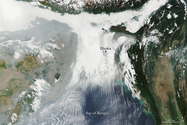
The cold has been visible as a cover over the northern Gangetic plains, a satellite image released by Nasa showed. On the ground, frost formed on crops, grasslands and car windscreens in and around Gurugram, while dense fog reduced visibility on highways and elevated roads during early morning hours.
The cold snap also coincides with persistent poor air quality, a common winter combination in north India. Calm winds and temperature inversions trap pollution close to the ground, worsening smog levels across Delhi and neighbouring states.
Weather officials have issued orange alerts for cold wave to severe cold wave conditions, warning of health risks including hypothermia, respiratory illness and increased strain on vulnerable groups such as the elderly and young children.
This winter has also been exceptionally dry, with north-west India recording rainfall deficits of more than 80 per cent in December and early January, leaving little snow cover in the hills and allowing cold air to spill freely across the plains.
Temperatures are expected to remain abnormally low for several more days before gradually rising later in the week, forecasters said, as cloud cover increases and winds weaken.
Join our commenting forum
Join thought-provoking conversations, follow other Independent readers and see their replies
Comments
Bookmark popover
Removed from bookmarks